CONTACT

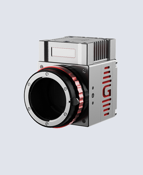
3D 포인트 및 디지털 지표면 생성
(3D Point & Digital Surface Generator)
이동식 측량과 고정식 측량을 결합한 솔루션입니다. 넓은 지역을 짧은 시간 안에 측량하는 SLAM의 장점 에 더해, 고정 모드에서는 더욱 높은 해상도로 스캔 할 수 있습니다. 모노포드에 장착하여 주요 영역에서 몇 초간 정지하는 것만으로 속도와 정밀도를 모두 구현합니다.
완벽한 데이터 정렬 및 오리엔테이션
(Never-failing Orientation)
소프트웨어가 GCP(지상기준점)와 상세 포인트를 자동으로 감지하여 작업자가 타겟 위치를 첫 단계에 서 즉시 확인할 수 있도록 돕습니다. 특히 Stonex타 겟을사용하면 정렬 시간이 단축되며, RTK 드론 데이 터와 연동할 경우 GCP 없이도 센티미터(cm) 급의 정밀한 정확도를 손쉽게 구현할 수 있습니다.
광범위한 데이터 호환성
(Wide Range of Import Options)
별도의 좌표계 선택이나 복잡한 포맷 설정 없이도 Cube-a의 데이터를 설정값 그대로 직접 수신하여 모델의 지오레퍼런싱(Georeferencing) 기준점으로 즉시 활용할 수 있습니다. 라이다(LiDAR), 레이저 스캐너 등 데이터를 생성하는 모든 도구의 포인트 클라우드를 제한 없이 가져올 수 있으며, 기존 표준 측량 포맷들과의 완벽한 호환성을 제공합니다.
01 제목이 들어가는 자리입니다
GOapp is Stonex SLAM’s dedicated mobile application to manage projects, real time point cloud display, image preview, firmware upgrade and other operations. The APP runs on Android and iOS operating systems.
01 제목이 들어가는 자리입니다
GOapp is Stonex SLAM’s dedicated mobile application to manage projects, real time point cloud display, image preview, firmware upgrade and other operations. The APP runs on Android and iOS operating systems.
01 제목이 들어가는 자리입니다
GOapp is Stonex SLAM’s dedicated mobile application to manage projects, real time point cloud display, image preview, firmware upgrade and other operations. The APP runs on Android and iOS operating systems.
01 제목이 들어가는 자리입니다
GOapp is Stonex SLAM’s dedicated mobile application to manage projects, real time point cloud display, image preview, firmware upgrade and other operations. The APP runs on Android and iOS operating systems.
제목이 들어가는 자리입니다.
제목이 들어가는 자리
내용이 들어가는 자리입니다.내용이 들어가는 자리입니다.내용이
들어가는 자리입니다.내용이 들어가는 자리입니다. 내용이 들어가는 자리

제목이 들어가는 자리입니다.
제목이 들어가는 자리
내용이 들어가는 자리입니다.내용이 들어가는 자리입니다.내용이
들어가는 자리입니다.내용이 들어가는 자리입니다. 내용이 들어가는 자리
제목이 들어가는 자리입니다.
제목이 들어가는 자리
내용이 들어가는 자리입니다.내용이 들어가는 자리입니다.내용이
들어가는 자리입니다.내용이 들어가는 자리입니다. 내용이 들어가는 자리
